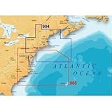
Magellan MapSend BlueNav XL3 Charts for Meridian Northeast U.S./Canyons Salt/Freshwater Map microSD Card
Magellan MapSend BlueNav XL3 Charts for Meridian Northeast U.S./Canyons Salt/Freshwater Map microSD Card
- Ideal for mariners who are looking for charts covering a large regional area
- Maps are based on the latest generation of Navionics Gold detailed marine cartography
- Simply insert the card into your Magellan Gold, Platinum, or Marine GPS or eXplorist series of handhelds
- Weighs 1.6 ounces
- Detailed maps on pre-programmed secure digital cards help enhance your journey through the Northeast United States and canyons
Pre-programmed large area marine charts on secure digital memory cards, Designed for mariners who are looking for charts covering a large regional area. Charts are based on the latest generation of Naionics Gold detailed marine cartography. Designed to be used ONLY with card capable products i.e. Meridian Series and Explorist series handhelds.Designed for use with the Meridian Gold, Platinum, and Marine Global Positioning Systems (GPS), the Magellan MapSend BlueNav XL3 Charts can enhance the enjoyment and safety of your journey through the Northeast United States and canyons. Ideal for mariners who are looking for charts covering a large regional area, these detailed maps on pre-programmed secure digital cards are based on the latest generation of Navionics Gold detailed marine cartography (Navionics chart number 1G904XL3). By taking advantage of these customized cards, you can expand the capabilities of your Magellan GPS handheld for easy navigation. You’ll also have a wealth of infor
List Price: $ 199.99
Price:
More Products

