Garmin XUS016R Micro SD Card
Garmin XUS016R Micro SD Card
- Chart-specific information including chart name and number scale revision date latest Notice to
- Object-oriented cartography
- Faithful representation of published official paper charts
- Shaded depth contours
- Intertidal zones
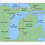
XUS016R Covers:Detailed coverage of Lake Michigan in its entirety and northern Lake Huron from Cheboygan MI to Blind River Ont. including Sault Ste. Marie and Cockburn Island.MapSource BlueChart serves up the best offshore cartography around and works in seamless integration with a wide range of Garmin products.Features Include:Chart-specific information including chart name and number scale revision date latest Notice to Mariners date Object-oriented cartography Faithful representation of published official paper charts Shaded depth contours Intertidal zones Spot soundings Navaids with view range and coverage Port plans Tides wrecks restricted areas and anchorages Trip and waypoint management functionsMicro SD Compatible Units:eTrex Legend Cx eTrex Vista Cx eTrex Venture Cx GPSMAP 60Cx GPSMAP 60CSx GPSMAP 76Cx GPSMAP 76CSxProduct : GARMIN BLUECHART MICRO SD XUS016R LAKE MICHIGAN Manufacturer : GARMIN CHARTS Manufacturer Part No : 010-C0351-00 UPC : 753759055806

Price: