Garmin MapSource Inland Lakes Northeast U.S. Freshwater Map microSD Card
Garmin MapSource Inland Lakes Northeast U.S. Freshwater Map microSD Card
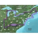
- Contains coverage of freshwater lakes in New England as well as New York, New Jersey, Maryland, Delaware, Virginia, West Virginia, Pennsylvania, Ohio, Indiana, lower Michigan and Kentucky
- Includes high resolution satellite imagery for selected lakes, providing you with unparalleled situational awareness
- Provides MarinerEye view for selected lakes, showing your surroundings in 3-D so you can gauge your position quickly and reliably
- Provides FishEye view for selected lakes, showing your surroundings below the waterline in 3-D, including bathymetric detail
- Includes Auto Guidance for selected lakes, which searches map data to recommend the best passage to a destination
You’ve never seen a lake like this before. Inland Lakes Vision — Northeast provides highly detailed maps of inland lakes, rivers and waterways. See shoreline, depth contours, bottom conditions, boat ramps, mile markers and more on your compatible chartplotter. View lakes in even richer detail with high-resolution satellite imagery and 3-D surroundings, both above and below waterline, for mariner’s-eye and fish-eye perspectives on the most popular lakes. Plus, get auto-guidance technology which simplifies navigation by suggesting the best routes. Maps also include wrecks and obstructions, river and creek channels, and major roads and highways.

List Price: $ 116.65
Price: $ 83.79
Ron
October 24, 2011Just what I was looking for.,
I wanted a high quality chart card and Garmin delivered…as expected. This card makes it easy to travel through shallow areas and areas with charted navigation hazards and using it with my new Garmin 420S, will even guide me through areas with a track line to follow. I simply move the pointer over to an area I want to go to and with a few clicks of a button, it plots me a safe course to get there based on minimum depth parameters that I enter in. I’ve been out twice this week using this system and so far I absolutely love it!!
Was this review helpful to you?

|