GARMIN BLUECHART MUS015R LAKE SUPERIOR
GARMIN BLUECHART MUS015R LAKE SUPERIOR
- With True Enhanced Performance.
- Latest Technical Development.
MUS015R Covers:
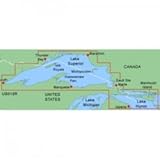
Lake Superior and northern Lake Huron are covered in detail for the U.S. portion from Duluth through Alpena, including Crooked Lake, Burt Lake, and Mullett Lake in Michigan; and for the Canadian portion from Thunder Bay to Tobermory, Ont.
MapSource BlueChart serves up the best offshore cartography around and works in seamless integration with a wide range of Garmin products.
Features Include:Chart-specific information, including chart name and number, scale, revision date, latest Notice to Mariners date Object-oriented cartography Faithful representation of published official paper charts Shaded depth contours Intertidal zones Spot soundings Navaids with view range and coverage Port plans Tides, wrecks, restricted areas and anchorages Trip and waypoint management functions
Compatible Units:GPSMAP 172cGPSMAP 172GPSMAP 178GPSMAP 178CGPSMAP 276CGPSMAP 3006CGPSMAP 376C

Price: