FlyBy Nav downloadable Software
FlyBy Nav downloadable Software
- Ram Used: 2300
- Resolutions:
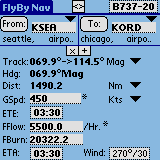
Flight planning is now as easy as tapping in your point of departure, arrival and winds! In one screen, FlyBy Nav displays track, distance, ground speed, time enroute, ETA, and fuel burn. Nearly all public airports and navigation aids in the U.S. are stored in its aviation database. Note: The program download from PalmGear H.Q. contains U.S. “Public Use” airports, U.S. navaids and some Canadian airports. Registered users will receive access to various airport files posted on our web site.

Price:
Find More Products