Plexscape partners with Birdi to offer up-to-date satellite imagery
Plexscape, developers of Plex.Earth, one of the most popular tools for AutoCAD for the acceleration of architectural, engineering and construction (AEC) projects, and Bird.i, a start-up that combines the latest satellite imagery and artificial intelligence technology to provide valuable business insights, are on a mission to change the way engineering projects are being designed by opening up access to high-quality geospatial data to the global AEC market.
Conventionally, the use of commercial satellite imagery is only possible through costly, time-consuming and inefficient processes, alongside the requirement for a certain level of expertise for processing and analysing the data.
Especially for engineering small and midsize businesses, its acquisition and usability are a significant challenge, and a competitive disadvantage, often leading to design errors, additional revisions, delays and ultimately, significant unexpected costs.
In addition, free imagery sources are often not precise enough, usually have outdated content and do not always provide sufficient permissions for commercial use or the creation of derivative work.
Through their strategic partnership, Plex.Earth and Bird.i, enable businesses of any size, in various sectors like construction, oil and gas, renewables, mining, asset intelligence, environmental monitoring, to bring satellite images, on-demand, right into AutoCAD and other CAD platforms.
This way they will be able to make more timely, better-informed design decisions and gain a competitive advantage by obtaining the most up-to-date and high-quality satellite imagery, quickly and easily.
“At Plexscape, we’re committed to changing the way engineers work on Architectural, Engineering and Construction (AEC) projects, by bridging the gap between design and the real-world”, said Mr. Lambros Kaliakatsos, Founder and CEO of Plexscape.
“For 10 years now, Plex.Earth, our flagship solution, helps thousands of engineers around the world to have the complete 3D geographical view of their project area, in every step of their design process. We strongly believe that our partnership with Bird.i will enable AEC professionals to design with the utmost confidence and take their processes to the next level via instant access to premium content.”
“Bird.i strives to unlock access to the best of the world’s satellite imagery, and the insight it contains” said Mr. Corentin Guillo, Founder and CEO of Bird.i.
“Applied to the construction sector, it allows for better forward planning and decision making, and can give greater context to the wider construction market in any given sector. This strategic partnership with Plex.Earth will accelerate the adoption of this new type of insight by the AEC industry to improve the entire project management process.”
Related Links
Plexscape
Earth Observation News – Suppiliers, Technology and Application
|
We need your help. The SpaceDaily news network continues to grow but revenues have never been harder to maintain. With the rise of Ad Blockers, and Facebook – our traditional revenue sources via quality network advertising continues to decline. And unlike so many other news sites, we don’t have a paywall – with those annoying usernames and passwords. Our news coverage takes time and effort to publish 365 days a year. If you find our news sites informative and useful then please consider becoming a regular supporter or for now make a one off contribution. |
||
|
SpaceDaily Contributor $5 Billed Once credit card or paypal |
SpaceDaily Monthly Supporter $5 Billed Monthly paypal only |
|

![]()
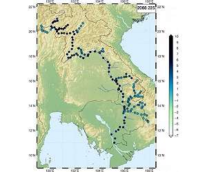
River levels tracked from space
Munich, Germany (SPX) Jan 30, 2019
Water levels in the Mekong basin, which extends through six countries in South-East Asia, are subject to considerable seasonal fluctuations. A new model now makes it possible to compute how water levels are impacted on various sections of the river by extreme weather events such as heavy rainfall or drought over extended periods.
To model the flow patterns of the river, with its complex network of distributaries, Claudia Kluppelberg, a professor of Mathematical Statistics at TUM, used statistical … read more
