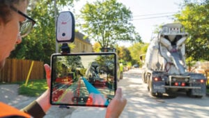
Mobile solutions: Higher accuracy blurs the lines between old

Photo: Leica Geosystems
Do you remember the free-standing car navigation devices that were popular for a while, such as those made by Garmin and Magellan? Few people use them anymore because to find our way when driving, most of us use our smartphones instead.
Smartphones now have a plethora of sensors, including inclinometers, accelerometers, magnetometers, barometers and light sensors. However, cost and size constraints (the insides of those small devices are so crowded!) limit the accuracy of smartphones’ GNSS receivers.
Therefore, to accomplish professional mapping tasks, it is now increasingly common to pair a smartphone — which provides computing power, a display, motion sensors, a camera and Internet connectivity — with an external GNSS receiver and antenna.
This and other changes in the industry make product categories long in use obsolete or, at least, less compelling. What is a mobile GNSS solution? Are the terms “mapping grade” and “resource grade” still useful? Who is using which devices for which tasks?
I discussed these issues with Bernhard Richter, VP Geomatics at Leica Geosystems, which is part of Hexagon, and with Igor Vereninov, CEO of Emlid.
— Matteo Luccio, Editor-in-Chief
Leica Geosystems: Conversation with Bernhard Richter, VP Geomatics at Leica Geosystems, part of Hexagon
We used to divide GNSS receivers into consumer grade, resource grade (for GIS data collection) and survey grade.
Those lines don’t exist anymore to the same extent. Some of the lower-cost chipsets — which were originally built for mobile phones and Garmin devices and lower-accuracy stuff — can now provide higher accuracy. We call them industrial-grade chipsets. The need for UAVs, e-scooters, e-bikes, automotive applications, etc., triggered their development. They are coming closer to the premium boards — let’s call them the multi-frequency, multi-constellation receivers that were always built for real-time kinematic (RTK)-type applications.
So, it’s the bottom that’s coming up.
There is still a need for single frequency code-only chips on the one hand for the mass market and, on the other hand, for premium devices from companies such as NovAtel (part of Hexagon), Trimble, Hemisphere and Septentrio. There is a new tier, which we call industrial grade, from companies such as u-blox and Unicore, which come a bit closer to the premium segment.
I’ve always thought of location-based services (LBS) as using consumers’ locations to connect them with retail and services. People use their smartphones to find the nearest coffeeshop, but what has not happened is coffeeshops saying, “Hey, I see that you are within 500 feet of our store. You should come in, because we’ll give you a discount.”
In our field, we make money by providing decimeter- or centimeter-level solutions to our users for surveying, machine control, GIS, etc. When it comes to needing locations for other applications, such as retail, everything is already nicely integrated in smartphones, and consumers just utilize what is there.
In order to get a better precision than the one provided by the cellphone, you need a small, extra GNSS device connected to the cell. Then, instead of using the position provided by the phone, the application will use that much better position. That trend will go on for quite a while. This is the change to what was standard in the last decade, when we built dedicated handheld controllers with fairly high-cost chipsets to enable GIS applications. These GIS devices seem to be disappearing. It’s either an Android or iOS-based phone or tablet, and now you add a hockey puck-type GNSS antenna. Then, you override or mock the position that is coming from the internal chipset on the phone, and the app uses that more precise position. That is the new standard for GIS, so to speak.
Analogously, for a decade we had dedicated car navigation devices. They disappeared because our phones now do that.
Exactly. Where we can really add is in providing that extra bit — not only hardware, but also software and services. Decades ago, we developed the HxGN SmartNet RTK service. Now, we also have HxGN SmartNetGlobal, which is both a terrestrial-based service and augmented by a satellite-based precise point positioning (PPP)-type service. Simple car navigation devices such as those by Garmin or dedicated GIS controllers have almost vanished. It’s always a smartphone or a tablet plus, if a centimeter-level solution is needed, an additional device.
It does not make a lot of sense to fully integrate high-precision GNSS into these mobile devices, because the customer group who really needs a centimeter-type solution is too small, and it would put an extra burden on the engineering for the tablet or the smartphone. Nobody complains if you attach a device that weighs a few hundred grams. I also think that you shouldn’t integrate things that don’t belong together. The different components have different life cycles….
