Lidar helps unlock secrets in Amelia Earhart mystery

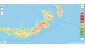
Elevation map of New Britain, Papua New Guinea. (Photo: topographic-map.com)
The Discovery Channel’s recently released “Finding Amelia” documentary explores the latest expedition aimed to uncover Amelia Earhart’s mysterious fate, featuring the participation of SPH Engineering. The film investigates the theory that Earhart and her navigator, Fred Noonan, may have crashed in Papua New Guinea during their 1937 attempt to circumnavigate the globe.
SPH Engineering joined the search nearly two years before the expedition, leveraging its experience from successful UAV operations in Greenland. The team’s mission focused on the dense jungles of New Britain, an island in Papua New Guinea, where they employed UAV technology to search for Earhart’s aircraft.

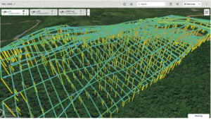
Planned routes for lidar scans in SPH Engineering’s UgCS flight planning software. (Photo: SPH Engineering)
Technology and challenges
The documentary follows the testing for the mission, which began in February 2021. The team conducted experimental detection of aircraft engines using UAV-mounted magnetometers. These experiments led the team to request satellite imagery and elevation maps of where the expedition was planned. This map was essential for studying the terrain and preparing for the mission. According to the analysis, the average expected vegetation height of 10 to 15 m allowed for the detection of aircraft engines using a magnetometer.
The SPH Engineering team arrived on-site with a suite of UAVs equipped with magnetometer, lidar and photogrammetry tools.
During the search, a small UAV equipped with a camera was first used to create precise maps of the search area. These maps were essential for planning subsequent flights. The team then conducted lidar scanning from a safe altitude to build digital surface models (DSM) and digital terrain models (DTM) to plan magnetic surveys.
The next step was to conduct the survey using a UAV-based magnetometer. The team found that while the average height of trees allowed for the detection of aircraft engines using a magnetometer, the presence of extremely tall trees made magnetic flight planning difficult.

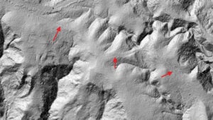
Processed lidar data showing potential Japanese troop trails. (Photo: SPH Engineering)
Janis Kuze, director of special projects for SPH Engineering explains the challenge. “In contrast to what we saw in satellite data available before the expedition, the average height of the trees was a bit greater, but the main problem was real ‘skyscrapers’ towering up to 60 m. These extremely high trees were totally missed in satellite elevation data. Despite the challenges, we had relative success detecting magnetic anomalies over the B-17 bomber crash site.”

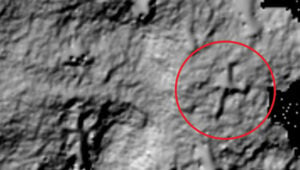
Processed lidar data showing the object resembling the shape and size of Amelia Earhart’s aircraft. (Photo: SPH Engineering)
Operation and results
Due to the high trees and the limited amount of magnetic ferrous metal in airplane engines, reliable detection using magnetometers proved difficult. The team then decided to switch back to lidar. Dozens of low-altitude lidar flights were conducted, using previous scans for flight planning, to build a detailed map of the ground surface beneath the trees.
The results revealed what is believed to be hidden Japanese troop trails and something resembling the shape and size of Amelia Earhart’s aircraft, the Lockheed Electra.
