Inside the new NSRS beta tools and a journey through geodetic
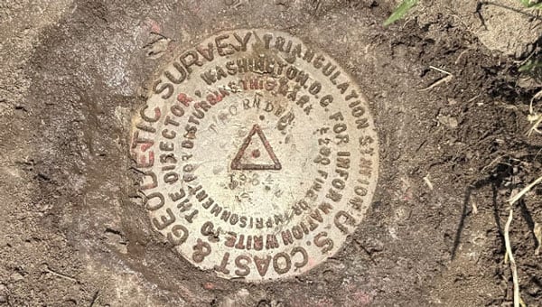 Thornden 1934 (Credit: Dave Zilkoski)
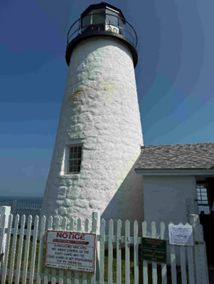
 This newsletter is going to highlight some history of the Coast and Geodetic Survey and provide the latest information on the National Geodetic Survey (NGS) new National Spatial Reference System (NSRS). First, every year my brother and I get together and travel to visit friends and relatives. He lives in Montana, and I live in North Carolina, so our yearly trips are typically 10 to 14 days long. As in all trips, I look for geodetic marks along the way. This year we traveled to coastal Maine to visit lighthouses and of course eat lobster rolls. We visited 12 Lighthouses along the Maine Coast. Lighthouses have both historical and navigational importance. The lighthouses were essential in guiding sailors through rocky shores. Portland Head Light commissioned by George Washington in 1791 is Maine’s oldest lighthouse and still guides vessels into Portland Harbor. We found NOS benchmark 841 8031 B 1979 on the grounds of this lighthouse. Pemaquid Point Lighthouse is managed by the Friends of Pemaquid Point Lighthouse, a chapter of the American Lighthouse Foundation, and remains an active aid to navigation under the ownership of the U.S. Coast Guard. We could climb up the Pemaquid Point Lighthouse, so I took a photo of the view from the top.

One of my brother’s requests was to visit the first place in the continental United States to see the sunrise. However, the location of the first place in the continental United States to witness the sunrise depends on the time of year. As indicated in the box titled “First Places to See the Sunrise in the Continental U.S.” Mars Hill is the first place to witness the sunrise in June.


First Places to See the Sunrise in the Continental U.S.
- October 7 to March 6: During these months, Cadillac Mountain in Acadia National Park, Maine, holds the distinction of being the first place in the continental U.S. to see the sunrise. Its elevation of 1,530 feet and eastern location make it ideal for early morning views. reddit.com+10nps.gov+10acadiamagic.com+10
- March 25 to September 18: In the spring and summer, Mars Hill in Aroostook County, Maine, takes the title. Its northeastern position allows it to catch the first rays of sunlight during this period. newengland.com+2en.wikipedia.org+2aa.usno.navy.mil+2
Around the Equinoxes: Approximately during the weeks surrounding the spring and fall equinoxes, West Quoddy Head in Lubec, Maine—the easternmost point of the contiguous U.S.—experiences the nation’s first sunrise. reddit.com+2en.wikipedia.org+2en.wikipedia.org+2
That said, when we travel together, we always recover geodetic marks, so we chose to visit Cadillac Mountain even though in June the first place is located on Mars Hill in Aroostook County.
As many of you know, I worked for NGS for 35 years so reconning monuments is exciting to me. We found six marks in a radius of about two hundred meters on Cadillac Mountain. We will talk about them in a minute.
Cadillac Mountain was important to me because from 1833 to 1898, the Coast and Geodetic Survey performed a triangulation project that extended from Calias, Maine, to New Orleans, Louisiana. The project was published as the Eastern Oblique Arc of the United States. The station Mount Desert 1856 that was located on Cadillac Mountain was part of this project. A report published in 1902 describes the Eastern Oblique Arc project and can be downloaded here.
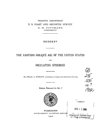
According to the 1902 report, horizontal observations at station Mount Desert 1856 were acquired by Alexander Dallas Bache. That may not mean much to most people, but Mr. Bache was the second superintendent of the Coast Survey and was particularly important to the advancement of geodesy in the United States. As a side note, the Coast Survey was renamed the Coast and Geodetic Survey in 1878. The change reflected the agency’s expanded mission beyond coastal charting to include geodetic surveys of the nation’s interior, prompted by the growing importance of geodesy in its work.
Bache’s leadership of the U.S. Coast Survey
In 1843, Bache was appointed superintendent of the United States Coast Survey, succeeding Ferdinand Rudolph Hassler. Under his leadership, the Coast Survey expanded its missions to include hydrography, geodesy, topography, and the printing arts. He initiated geomagnetic studies, directed tide observers to make meteorological observations, and developed mathematical techniques for tide predictions and adjusting triangulation networks. Bache’s administrative skills transformed the Coast Survey into one of the foremost scientific…