DOT report: L-band, UHF, LF and fiber PNT needed to protect US
In a report issued on Jan. 14, the Department of Transportation (DOT) outlined the results of its GPS Backup Technology Demonstration project. As officials had previously projected, it called for a system-of-systems approach using multiple complementary technologies.
The report called for an architecture that included signals from space in the L-band, terrestrial broadcasts in the ultra high frequency (UHF) and low frequency (LF) spectra, and a fiber backbone to synchronize and feed precise time to terrestrial transmitters.
The demonstration project and report were mandated by Congress in legislation passed in late 2017 and funded in early 2018. Delays within the administration resulted in the project beginning in early 2019.

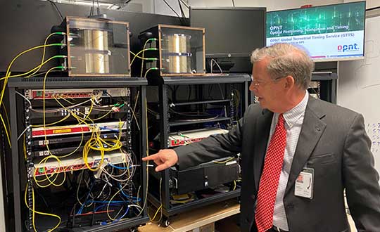
Monty Johnson of OPNT demonstrates precise time transfer through 100 kilometers of spooled fiber-optic cable. (Photo: RNT Foundation)
Demonstrations
Of 21 firms that offered to demonstrate their wares, 11 were selected. They were:
- Echo Ridge LLC and Satelles Inc. Satellite-based PNT technologies using the S and L bands, respectively.
- OPNT B.V. and Seven Solutions S.L. Fiber-optic time transfer using the White Rabbit Precision Time Protocol technology.
- TRX Systems Inc. Dead reckoning technology with inertial measurement units and localized map matching supplemented with ultra-wideband beacons.
- Hellen Systems LLC and UrsaNav. eLoran that uses LF transmissions.
- Serco Inc. Medium frequency R-mode.
- NextNav LLC. Metropolitan beacon system using UHF frequencies.
- PhasorLab Inc. and Skyhook Wireless Inc. Both use Wi-Fi frequencies. Phasorlab uses a dedicated network of transmitters. Skyhook leverages existing Wi-Fi access points.
Five of the demonstrations were conducted at Joint Base Cape Cod, with the remainder at NASA’s Langley Research Center in Virginia.
Timing demonstrations were assessed for system:
- coverage (service availability) within an “appropriate area” (wireless systems only)
- accuracy and stability across an appropriate area
- long-term accuracy and stability of time transfer to a fixed location
- time transfer availability and accuracy to a fixed location under challenged GPS signal conditions.
Positioning was evaluated for:
- coverage within a defined region
- 2D and 3D dynamic positioning service availability and accuracy
- availability and accuracy of static positioning
- long-term availability and accuracy of static positioning
- long-term availability and accuracy of static positioning under challenged GPS signal conditions
DHS work referenced
The report also mentions an earlier set of demonstrations done by the Department of Homeland Security (DHS).
In December 2018, DHS’s Science and Technology Directorate performed the work through the Homeland Security Systems Engineering and Development Institute. The project “demonstrated a combination of position and timing use cases for dynamic vs. static and indoor vs. outdoor applications, along with a time-transfer use case for critical infrastructure applications.” Systems from Locata Corp, NextNav, and Satelles were evaluated.
The DoT report says that eLoran was not part of the DHS effort because of the lack of transmitters in the area. However, “DHS had previously studied eLoran performance under a Cooperative Research and Development Agreement (CRADA) with Harris Corporation and UrsaNav and had an understanding of its capabilities.”
A report of DHS’ December 2018 work is not publicly available, though DOT says it was used to inform their efforts.
The only publicly available information from DHS about the eLoran CRADA seems to be a 2016 press release. A presentation and other information is available on the UrsaNav website.
Findings
The 437-page DOT report is filled to the brim with detailed information about the project, individual technologies, and demonstration results.
The Executive Summary says that, in addition to the findings from the DHS December 2018 effort (which were not listed), the DOT demonstration had four key findings:
- All TRL-qualified vendors offered showed PNT “performance of value” and one showed value in all scenarios.
- Neither eLoran company succeeded in the Static Basement Timing scenario.
- R-mode ranging did not meet the minimum technical readiness level (TRL) of 6.
- Deployment effort and coverage (infrastructure per unit area) are significant cost factors.
Addressing the needs of critical infrastructure owners and operators, the report concluded the needed “technologies are LF and UHF terrestrial and L-band satellite broadcasts for PNT functions with supporting fiber optic time services to transmitters/control segments.”
Reactions and way forward
Government officials and industry observers alike have welcomed the report, though it does leave some questions on the table.
One is about other national PNT needs. The congressional tasking was to report on GPS backup technologies for critical infrastructure and national security. The Jan. 14 report focuses on critical infrastructure needs….
