Launchpad: Software updates, defense radar, fleet tracking and more
A roundup of recent products in the GNSS and inertial positioning industry from the October 2024 issue of GPS World magazine.
SURVEYING & MAPPING
 Updated CAD Software
With enhanced features and workflow improvements
Topcon Positioning Systems has released a new version of its computer-aided design (CAD) software suite, formerly known as MAGNET. With enhanced features and workflow improvements to the Office, Field and Tools modules, version 9 is also renamed under the Topcon software suite as the business retires the MAGNET brand.
The software is designed for professionals such as surveyors, engineers, modelers, estimators and project managers, aiming to improve productivity through integrated software capabilities and workflows. It can be used as standalone, office-based CAD software or as a cloud-connected solution that integrates field and office operations with Topcon or Sokkia survey instruments. The platform offers user-friendly and versatile configurations suitable for various applications.
Topcon Office version 9 introduces new options for working with digital terrain models (DTMs), spot elevations and offset capabilities, enhancing versatility when handling 2D or 3D data sets. Improvements in Topcon Field include better productivity and stake reporting capabilities, advanced resection functionality for unknown control points and a new offset routine for creating points that are not observable with a total station. Both Field and Office modules now support direct import and export with 12D XML file formats.
Subscribers to the AllDayRTK high accuracy positioning network can now directly import and export RINEX data into Topcon Tools with a current Plus or RINEX subscription. Version 9 of Topcon Tools also features improved coordinate system functions, new traverse calculations, viewing options and enhanced functionality for working with data in tabular view for reporting.
Topcon Positioning Systems, topconpositioning.com
 4D Scanner
For AEC professionals
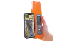
The PIX4Dcatch smartphone scanning application is now compatible with the Bad Elf FlexGNSS receiver. This integration is designed for professionals in the architecture, engineering and construction (AEC) industries.
PIX4Dcatch is a comprehensive 3D scanning and AR visualization tool that combines photogrammetry, lidar technology and real-time kinematic (RTK) positioning for precise results.
The Bad Elf Flex GNSS receiver offers scalable accuracy and flexibility. In its standard configuration, it provides 30-60 cm real-time accuracy for GIS applications. Its daily token model allows users to unlock full RTK workflow for 24-hour periods, achieving 1 cm horizontal accuracy when needed. For users requiring consistent high accuracy, an upgrade to the Bad Elf Flex Extreme is available for permanent RTK capabilities.
By combining PIX4Dcatch with the Bad Elf Flex GNSS receiver, surveying, construction and building professionals can now create highly accurate 3D models using mobile smartphone scanning technology. The resulting scans can be exported to CAD/GIS platforms for inspection, sharing and collaboration among project stakeholders.
Bad Elf, bad-elf.com
UAV
With an integrated bathymetric system
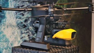
 The YellowScan Navigator bathymetric system has been integrated into Xer Technologies’ UAVs. This collaboration aims to enhance UAVs’ capabilities for conducting long-range bathymetric surveys and underwater inspections, which are essential in various fields such as environmental monitoring, coastal management and infrastructure development.
The integrated system allows users to collect high-resolution and accurate bathymetric data, even in challenging aquatic environments. YellowScan’s green laser lidar technology is a key component of this system, providing precise underwater mapping capabilities. Xer Technologies’ UAVs are designed for extended flight durations and can operate for more than two hours, facilitating coverage of larger survey areas in a single mission. This feature is particularly beneficial for projects that require extensive data collection over vast aquatic regions.
The YellowScan Navigator can achieve a precision of 3 cm and can operate at a maximum altitude of 100 m above ground level. The laser has a range of up to 120 m and features a scanner field-of-view of 44°. It weighs 3.7 kg.
Xer Technologies, xer-tech.com
Sonar Series
For underwater applications
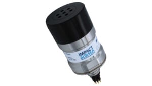
 The ISS360 Sonar Series is a range of imaging sonars designed for underwater applications. This series provides a full 360° field of vision and can detect objects at distances of up to 90 m to 100 m. The ISS360 utilizes compressed high-intensity radar pulse (CHIRP) acoustics to provide image clarity and quality.
The ISS360 operates within a frequency range of 600 kHz to 900 kHz, offering an angular resolution of 2.2° at 700 kHz and a range resolution of 2.5 mm at lower ranges. The sonar is housed in durable titanium material, providing a depth rating of 4,000 m as standard, with an…
