New BeiDou satellite starts operation in network
The 45th satellite of the BeiDou Navigation Satellite System (BDS) has started operation in the network after completing in-orbit tests, according to the Satellite Navigation System Management Office.
The satellite will provide services in place of the 3rd BeiDou satellite, a geostationary earth orbit satellite of the BDS-2 system. The replacement will help reinforce the BDS-2 system and support a smooth transition from the BDS-2 system to the BDS-3 system. The third satellite will stay in orbit after the replacement, said a source of the office.
The third and the 45th satellite were launched at the Xichang Satellite Launch Center on Jan. 17, 2010 and May 17, 2019, respectively. Both were developed by the China Academy of Space Technology.
The BDS is China’s independently developed and operated global navigation system. It is named after the Chinese term for the Big Dipper constellation.
Chinese scientists started to build the BDS-3 system in 2009. Compared with the BDS-2 system, the technologies of the BDS-3 system have been greatly improved.
Source: Xinhua News Agency
Related Links
BeiDou Navigation Satellite System
GPS Applications, Technology and Suppliers
|
We need your help. The SpaceDaily news network continues to grow but revenues have never been harder to maintain. With the rise of Ad Blockers, and Facebook – our traditional revenue sources via quality network advertising continues to decline. And unlike so many other news sites, we don’t have a paywall – with those annoying usernames and passwords. Our news coverage takes time and effort to publish 365 days a year. If you find our news sites informative and useful then please consider becoming a regular supporter or for now make a one off contribution. |
||
|
SpaceDaily Contributor $5 Billed Once credit card or paypal |
SpaceDaily Monthly Supporter $5 Billed Monthly paypal only |
|

![]()
Velodyne Lidar announces multi-year sales agreement with GeoSLAM
San Jose CA (SPX) May 08, 2020
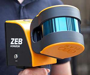
Velodyne Lidar, Inc. has announced a multi-year sales agreement with GeoSLAM, a global market leader in 3D geospatial technology solutions. GeoSLAM uses Velodyne lidar sensors in its ZEB-HORIZON mobile scanner that provides 3D mapping of indoor, underground and difficult to access environments without the need for GPS.
Velodyne’s Puck LITE sensors enable GeoSLAM systems to achieve data capture of intricate measurements from up to 100 meters away, delivering rapid results that can save time and mon … read more
