Garmin GPSMAP 4208 Chartplotter Reviews
Garmin GPSMAP 4208 Chartplotter
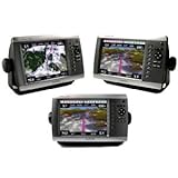
010-00591-01 This preloaded, offshore chartplotter combines the power of networking with brilliant color and slim-line design. The GPSMAP 4208 has preloaded BlueChart® g2 maps of the U.S. coast and displays them on an 8.4? VGA display with video-quality resolution. By connecting to the Garmin Marine Network, you can add sonar, radar and weather. For even more enhanced features, you can add the optional Bluechart g2 Vision card. The 4208 features highly-detailed BlueChart g2 marine cartography of the coastal United States, including Alaska, Hawaii and the Bahamas. This data provides detailed coastlines, shaded depth contours, navaids, port plans, wrecks, restricted areas and tide and current information. For other areas, the 4208 has a worldwide basemap with high-quality satellite images in place of more traditional maps. With the SD card slot, you can add additional maps without having to connect to a computer. The 4208?s high-speed processor draws maps quickly, and its simple intuiti

Price: