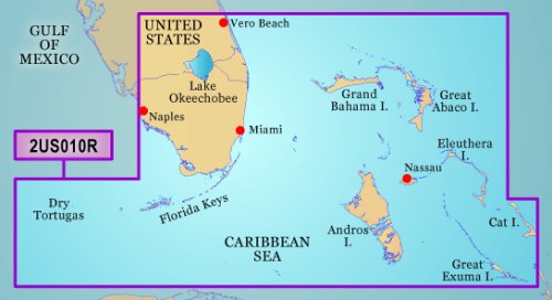
Garmin BlueChart g2 Southeast Florida Salt/Freshwater Map microSD Card
- BlueChart G2 Features Smoother Layering/Better Integration Of Map Graphics
- More Cohesive Panning/Scrolling/Zooming – Features Ficher Colors And Shading
- For Vero Beach South to Lake Okeechobee/Florida Keys/ Dry Tortugas
- Featuring Data From Explorer Charts For The Bahamas
- West Coast Florida North To Naples/Bahamas/Andros/ Eleuthera Island And More
The next generation of marine cartography, BlueChart g2. The new BlueChart g2 has a much smoother presentation on the plotter display, because the charts are electronically layered. It has all the detail of traditional BlueChart, but with additional functions like an optional 3D perspective, and tides and currents overlaid on the chart. Additional enhancements include general coastal road detail, marine services information, and improved IALA navigational symbols. Other chart features include shaded depth contours, port plans, wrecks, restricted areas, and more.All of these elements of BlueChart g2 technology for the coastal United States (including Alaska and Hawaii) are built-in on Garmin’s new GPSMAP 492 and GPSMAP 498 chartplotters, as

Gps Maps South America